

Title
IODP Site survey ADCP mooring dataset
IODP_SITE_SURVEY_KY09-04_KY10-06.zip (4.45 MB) 
IODP_SITE_SURVEY_KY12-06_KY13-06.zip (29.52 MB)
IODP_SITE_SURVEY_YK10-06_YK10-E02.zip (8.63 MB)
IODP_SITE_SURVEY_YK14-10_KY15-E04_01.zip (30.18 MB)
IODP_SITE_SURVEY_YK14-10_KY15-E04_02.zip (39.34 MB)
Abstract
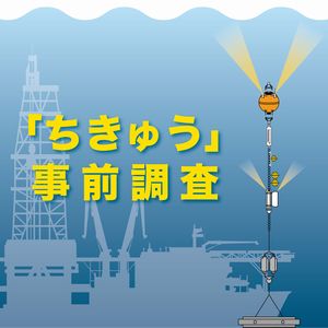
CDEX (1) carried out some site surveys for operational purposes for IODP (2) campaigns separately from those conducted by proponents of drilling proposals. Long-term ocean current monitoring using subsurface mooring systems is one of the site surveys, obtaining ocean current data to assess the impacts of those on the drilling operations. The mooring system consists of a long ranger multi-current ADCP (3) at the top buoy, which is designed to locate at 300-500m below sea level, single-point doppler current meters and CTDs (4) aligned below the top buoy, a pair of acoustic releasers, and an anchor at the sea bottom. Here, long-term ocean current directions and velocities, temperatures, and conductivities obtained by the mooring systems near the IODP drilling sites or proposed drilling sites are available. (1) Center for Deep Earth Exploration (2002~2019), the previous IODP Implementation Organization of Japan operating D/V Chikyu. (2) Integrated Ocean Drilling Program (2003~2013) or International Ocean Discovery Program (2013~2024) (3) Acoustic Doppler Current Profiler (4) Conductivity Temperature Depth profiler.
Data Set Citation
Dataset Creator
CDEX
Dataset Title
IODP Site survey ADCP mooring dataset
Other Citation Details
Data Citation: CDEX/JAMSTEC (2017) IODP Site survey ADCP mooring dataset. JAMSTEC. doi:10.17596/0000028 (accessed YYYY-MM-DD)
Persistent Identifier
Type
DOI
Identifier
10.17596/0000028
Personnel
Role
TECHNICAL CONTACT
Contact
cdex-gg@jamstec.go.jp (cdex-gg@jamstec.go.jp)
Keyword List
ISO Topic Category
OCEANS
Parameter
EARTH SCIENCE>OCEANS>OCEAN CIRCULATION>OCEAN CURRENTS
Platform
ADCP>Acoustic Doppler Current Profiler
Other
JAMSTEC
chikyu site survey
Ocean Current survey
Bounding Rectangle
- South Bound
- 32.00
- North Bound
- 32.83
- West Bound
- 139.67
- East Bound
- 141.00
- South Bound
- 33.00
- North Bound
- 33.50
- West Bound
- 136.17
- East Bound
- 136.83
Location
OCEAN>PACIFIC OCEAN>NORTH PACIFIC OCEAN>Northern Izu-Ogasawara Arc>YK14-1/KY15-E4>IBM-4
OCEAN>PACIFIC OCEAN>NORTH PACIFIC OCEAN>Northern Izu-Ogasawara Arc>KY9-4/KY1-6>IBM-4
OCEAN>PACIFIC OCEAN>Kumano Basin>KY12-6/KY13-6
OCEAN>PACIFIC OCEAN>Kumano Basin>YK1-6/YK1-E2
Project
Short Name
IODP
Long Name
International Ocean Discovery Program
Use Constraints
To use data, please contact dmo@jamstec.go.jp. JAMSTEC Data Policies: https://www.jamstec.go.jp/e/database/data_policy.html
Originating Center
JAMSTEC
Organization
Organization Type
ORIGINATOR
Organization Name
Short Name
JAMSTEC
Long Name
Japan Agency for Marine-Earth Science and Technology
Personnel
Role
DATA CENTER CONTACT
Contact
dmo@jamstec.go.jp (dmo@jamstec.go.jp)
Organization Name
Short Name
MarE3
Long Name
Institute for Marine-Earth Exploration and Engineering
Personnel
Role
DIF AUTHOR
Contact
cdex-gg@jamstec.go.jp (cdex-gg@jamstec.go.jp)
Related URL
Description
Related Cruise information YK14-10
Description
Related Cruise information Y15-E04
Description
Related Cruise information KY09-04
Description
Related Cruise information KY10-06
Description
Related Cruise information KY12-06
Description
Related Cruise information KY13-06
Description
Related Cruise information YK10-06
Description
Related Cruise information YK10-E02
Description
IODP Site survey ADCP mooring dataset - Catalog Page
Last Metadata Revision Date
2022-11-24