

Title
Fine resolution basin database provides basin model over 10 ha sub basins of the Sanriku coastal area, Japan (watershed boundary, flow path data)
JAMSTEC-R_28DP01.zip (329.87 MB) 
Abstract
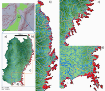
This fine resolution basin database provides basin model over 10 ha sub basins of the Sanriku coastal area, Japan located in the north west Pacific. The data contain watershed boundary, flow path data, flow accumulation and flow direction about the target area created by use of a 10m digital elevation model (DEM).
Data Set Citation
Dataset Creator
Tohoku Ecosystem-Associated Marine Sciences (TEAMS)
Dataset Title
Fine resolution basin database provides basin model over 10 ha sub basins of the Sanriku coastal area, Japan (watershed boundary, flow path data)
Dataset Publisher
Takehisa Yamakita
Other Citation Details
CC-BY 4.0 Yamakita, T., & Imaki, H. (2019). Fine resolution basin database using 10m DEM at the area along Sanriku coast of Japan. JAMSTEC Report of Research and Development, 28, 54-60.
Personnel
Role
DIF AUTHOR
Contact
Marine Biodiversity and Environmental Assessment Research Center (BioEnv) Eastern Japan Marine Ecosystems Dynamics Project Team of JAMSTEC JAMSTEC (tohoku_team6@jamstec.go.jp)
Role
TECHNICAL CONTACT
Contact
Takehisa Yamakita (yamakitat@jamstec.go.jp)
Keyword List
ISO Topic Category
INLAND WATERS
GEOSCIENTIFIC INFORMATION
Parameter
EARTH SCIENCE>LAND SURFACE>GEOMORPHIC LANDFORMS/PROCESSES>GIS (Geograhic information system)
Platform
Other
JAMSTEC
JAMSTEC-R
Start Date - End Date
- - 2009-05-10
Bounding Rectangle
- South Bound
- 38.2
- North Bound
- 40.19
- West Bound
- 140.41
- East Bound
- 142.07
- Minimum Altitude
- 0
Project
Short Name
TEAMS
Long Name
Tohoku Ecosystem-Associated Marine Sciences (TEAMS)
Originating Center
JAMSTEC
Organization
Organization Type
ORIGINATOR
Organization Name
Short Name
JAMSTEC
Long Name
Japan Agency for Marine-Earth Science and Technology, Japan
Personnel
Role
DATA CENTER CONTACT
Contact
dmo@jamstec.go.jp (dmo@jamstec.go.jp)
Distribution
Distribution Size
343723716 byte
Distribution Format
ESRI Shape File and Two Geotiff file
Related URL
Description
TEAMS Data Catalog is the collection of the information of Research and Observation Data obtained through the activities of Tohoku Ecosystem-Associated Marine Sciences (TEAMS) from FY2011 to FY2020.
Description
Fine resolution basin database provides basin model over 10 ha sub basins of the Sanriku coastal area, Japan (watershed boundary, flow path data) - Catalog Page
Last Metadata Revision Date
2022-11-18